Which Canyonlands District Should You Visit?
A Side by Side Comparison

Tucked away along a trail in the rugged, remote wilderness of Canyonlands National Park is a sign that reads:
"Here at the end of the road, we encourage you to step into the wilderness and explore what it means to you."
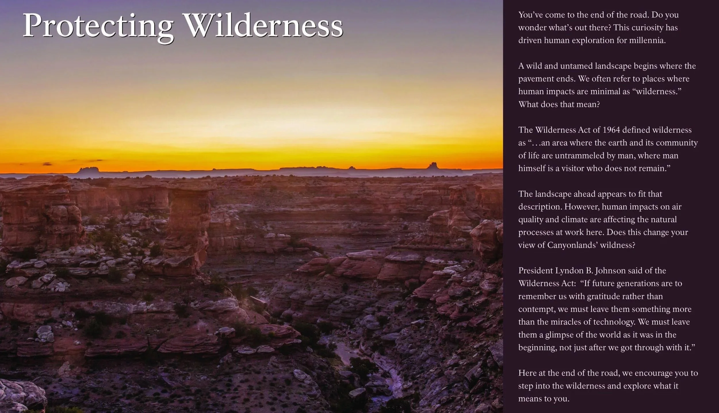
Standing there in what truly felt like the end of the road, those words struck a chord with me, and I snapped a photo of the sign. Little did I know that years later, after starting a travel blog, I'd find myself returning to that moment.
There's something different about Canyonlands. Unlike many national parks, it has an incredible sense of solitude and scale. Standing on the edge of its vast canyons, it feels as though you've stepped into another world—one that is wild, quiet, and seemingly endless.
👉 Planning your visit? Be sure to check out my Complete Guide to Canyonlands National Park, where you'll find more detailed information on everything you need to know about the park's districts, camping, permits, weather, and planning your trip.

Side-by Side Comparison Chart of Canyonlands Districts
If you're short on time, this comparison chart will help you quickly decide which Canyonlands district is best for you.
| Feature | Island in the Sky | The Needles | The Maze | Horseshoe Canyon |
|---|---|---|---|---|
| ⭐ Best For | First-time visitors | Hiking | Remote adventures | Ancient rock art |
| 📍 Drive from Moab | 35–45 min | 75–90 min | 2–6 hrs* | ~2 hrs |
| ⏰ Time Needed | ½–1 day | 1 day | 2–4 days | ½ day |
| 🥾 Hiking | ⭐⭐⭐⭐ | ⭐⭐⭐⭐⭐ | ⭐⭐⭐⭐⭐ | ⭐⭐⭐ |
| 📸 Photography | ⭐⭐⭐⭐⭐ | ⭐⭐⭐⭐ | ⭐⭐⭐⭐⭐ | ⭐⭐⭐⭐ |
| 🚙 4WD Required? | No | No* | Yes | High clearance recommended |
| 👨👩👧 Family Friendly | ⭐⭐⭐⭐⭐ | ⭐⭐⭐⭐ | ⭐⭐ | ⭐⭐⭐ |
*Most attractions in The Needles area are accessible by paved roads, but some backcountry routes require high-clearance or four-wheel-drive vehicles.
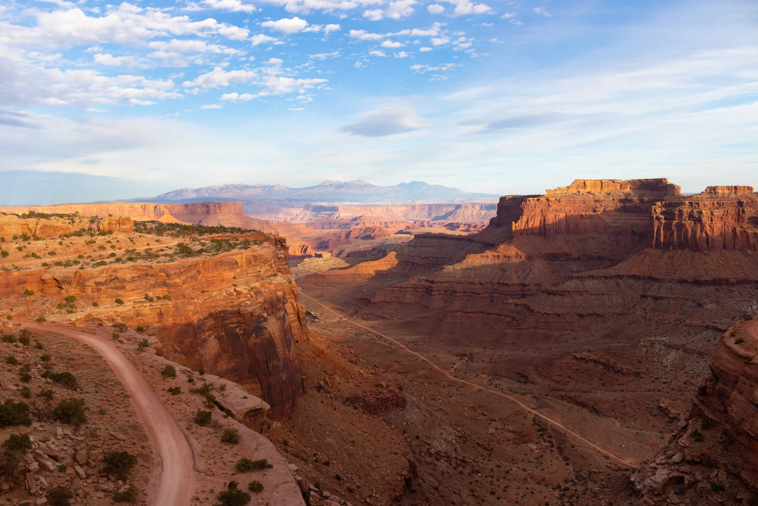
Why Canyonlands is Different Than Other National Parks
Covering more than 330,000 acres, of dramatic desert in southeastern Utah, Canyonlands is a landscape of sandstone walls carved by the Colorado River and its tributaries and eroded with time, leaving behind a huge flat-topped mesa full of panoramic outlooks, miles of maze-like canyons, sheer cliff drop-offs, pinnacles, and flats. It’s a red rock paradise of sweeping, jaw-dropping views, wind-swept rocks and plateaus, where the Green River and the Colorado intersect.
What makes Canyonlands truly unique, however, isn't just its scenery. It's its layout and how desolate and vast it is.
Compared to many other national parks, Canyonlands is huge - divided into four distinct separate districts (5 regions if you include its rivers) none of which are connected by roads. This requires substantially more planning than other parks.
While each district belongs to Canyonlands National Park, they each offer completely different experiences and require returning to surrounding highways to reach the next one.
This is not to say you can’t do a quick visit and drive through some parts of it, but if you plan to spend more than a few hours ther, you will definitely need to do your research.
👉 Before visiting, be sure to get my Complete Guide to Canyonlands National Park.
🧭 Canyonlands at a Glance
If you only have one day in Canyonlands National Park, visit Island in the Sky. If you have two days, add The Needles. Save The Maze for a future trip unless you're planning a multi-day backcountry adventure.
Still not sure? Here's a quick comparison to help you choose the district that's right for your trip.
⭐ Best Overall for First-Time Visitors: Island in the Sky
📍 Closest to Moab: Island in the Sky (35–45 minutes)
🥾 Best Hiking: The Needles
📸 Best Sunrise + Photography: Island in the Sky
👨👩👧 Best for Families: Island in the Sky
🌅 Best Scenic Overlooks: Island in the Sky
🚙 Best 4WD Adventures: The Maze
🪨 Best Ancient Rock Art (Petroglyphs): Horseshoe Canyon
🌌 Best Stargazing: The Maze & The Needles
⏰ Time Needed:
Island in the Sky: ½ - 1 day
The Needles: 1 full day
The Maze: 2–4 days
Horseshoe Canyon: ½ day
🚗 Can You Visit All Four?
yes but you will need to plan on spending 3-4 days due to the long drives between districts and the fact there are no direct routes between each region.
Which Canyonlands District is Best for You?

One of the biggest surprises for first-time visitors is just how spread out and vast Canyonlands National Park really is.
Although the four districts may look close together on a map, there are no roads connecting them inside the park. Driving between them can take anywhere from 2-6 hours, making it difficult to visit more than one district in a single day, let alone a single trip. The good news is that each one is incredible, offerring a completely different experience that won’t disappoint.
Whether you're looking for iconic overlooks, challenging hikes, remote backcountry adventures, 4-wheel technical roads, or some of the most amazing ancient rock art in North America, there's a district that's perfect for you.
Here’s a closer look at each once to help you decide.
Island in the Sky
⭐ Easiest access for first time visitors.
Overview
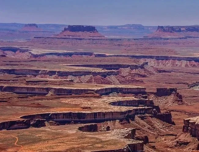
The Island in the Sky mesa is perched atop 1,000-foot sandstone cliffs making it one of the most scenic and most visited district. It offers some of the most spectacular panoramic views in the American Southwest.
It’s the perfect introduction to Canyonlands National Park.
Must-See Highlights
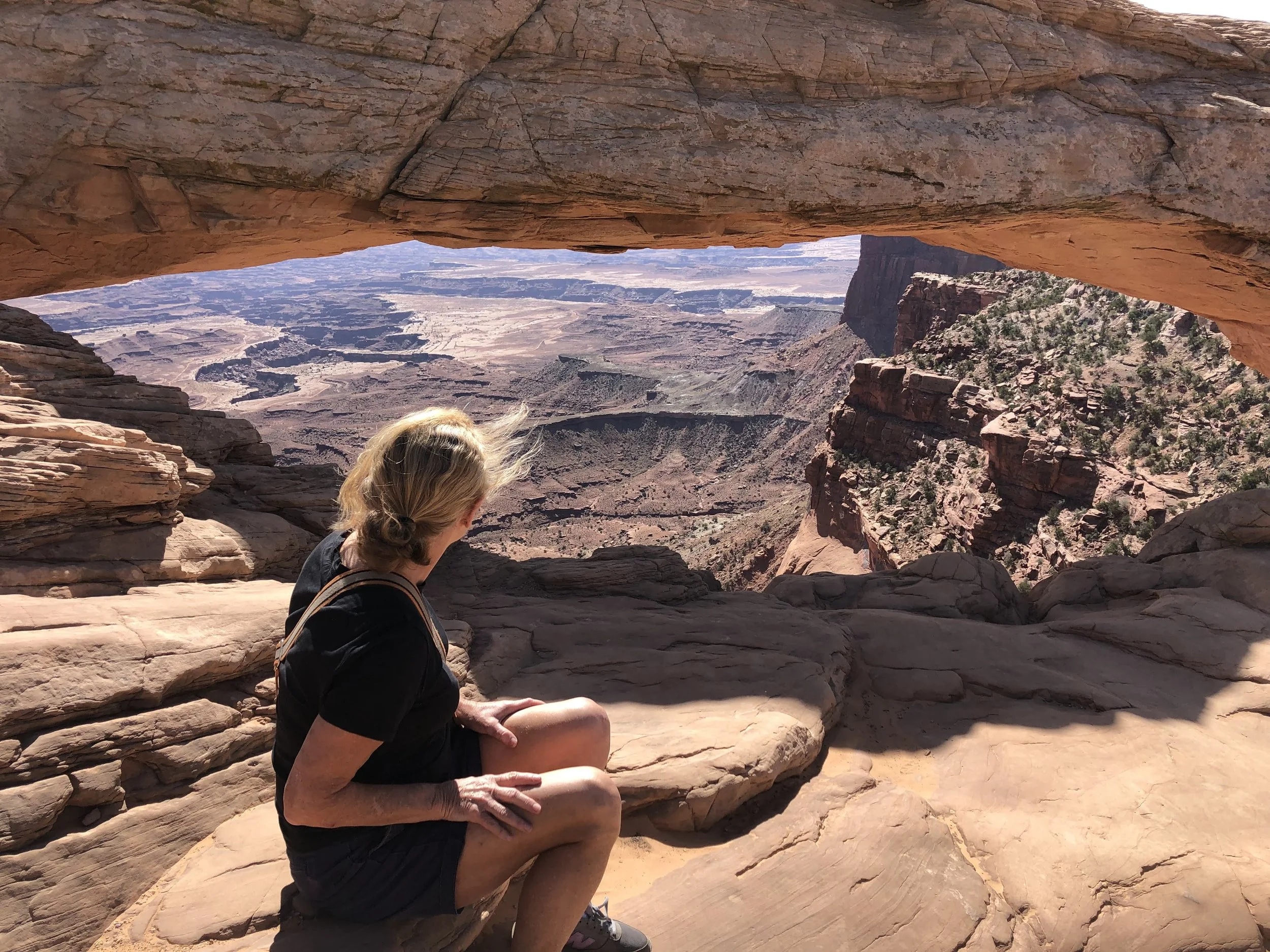
Mesa Arch
Grand View Point Overlook
Green River Overlook

Shafer Canyon Overlook
White Rim Overlook
Upheaval Dome
Numerous short hiking trails and overlooks
💧 Water is available at the Island in the Sky Visitor Center, making it one of the few places within Canyonlands where visitors can refill water bottles.
👉 For a more comprehensive list of things to do at Island in the Sky, get my Complete Guide to Canyonlands National Park.
Best For
Island in the Sky is best for first time visitors to Canyonlands. It is a quick day trip from Moab and easy to explore if you have limited time.
⭐ First-time visitors
📸 Photography
🌅 Scenic overlooks
👨👩👧 Families
🚗 Travelers with limited time
Time Needed
Although you can easily spend just half a day here, try to allow for a full day in order to have time to enjoy the scenic overlooks, short hikes, and visitor center without feeling rushed.
Distance from Moab
Approximately 35–45 minutes from downtown Moab.

Difficulty
Island in the Sky is the most accessible district in Canyonlands National Park. Paved roads lead to nearly all of the major viewpoints, and a four-wheel-drive vehicle is not required for the park's main attractions.
⭐ My Recommendation
If this is your first visit to Canyonlands National Park, this is where I would spend your time. Island in the Sky combines the park's most iconic scenery with easy access, making it ideal for day trips from Moab and visitors who want to experience Canyonlands without venturing deep into the backcountry.
The Needles
⭐ Best hiking.
⚠️ ALERT: As of 6/28/26 (updated 6/30/26) Canyonlands National Park has temporarily closed The Needles district to all uses, including the backcountry, until further notice due to the Babylon Fire near Blanding, Utah.

Overview
Named for its colorful sandstone spires that rise from the desert floor, The Needles is Canyonlands' premier destination for hiking, backpacking, and backcountry adventure.
While The Needles is easily accessible by paved roads, many of its most remote gems, ncluding rugged backcountry roads and hidden canyons, require a high-clearance or 4-wheel-drive vehicle to explore.
It is renowned for breathtaking rock formations, incredible hiking trails, ancient pictographs, and quiet wilderness. Compared to Island in the Sky, it is much more remote with fewer visitors, making it an excellent choice for those looking to escape in nature.
Must-See Highlights
Lavendar Canyon
Elephant Hil Trail
Chesler Park Loop
Druid Arch
Cave Spring
Newspaper Rock (just outside the park entrance)
👉 For more detailed information on things to do in The Needles district, get my Complete Guide to Canyonlands National Park.
Best For
🥾 Hiking and Backpacking
🚙 Four-wheel-drive adventures
🪨 Ancient rock art/pictographs
🌄 Visitors wanting solitude
Time Needed
Plan to spend at least one full day exploring The Needles. If you want to do longer hikes, backpack, or drive the backcountry roads, consider spending at least 2-3 more days.
Distance from Moab
Approximately 75–90 minutes from downtown Moab.
Difficulty
The Needles is more physically demanding than Island in the Sky. While the district itself is easy to reach by car, many of its best hikes are longer and more strenuous, and several backcountry roads require a high-clearance four-wheel-drive vehicle and a permit.
⭐ My Recommendation
If you've already visited Island in the Sky or you are seeking more adventure and more technical hikes, The Needles is my recommendation. Its dramatic sandstone formations, scenic trails, and quieter atmosphere make it one of the most impressive areas in Canyonlands National Park.
The Maze
🚙 Most remote adventures.
Overview
The Maze is an extremely remote area of the park to the west of the Green River that is completely isolated and a haven for remote backpacking, strenuous hiking and off roading. It is the least accessible district of Canyonlands with the fewest visitors.
The Maze itself is 30 square miles of of sheer 600-foot walled canyons that wind about, twisting and dividing back upon themselves that can only be explored by foot. This slew of interwoven canyons often lead to dead ends and is often referred to as a “thirty mile puzzle in sandstone.”
✨ Pro Tip: Like many areas of Canyonlands, GPS often leads one astray, so be sure to take a topographical map of the area so you don’t get lost. It can literally take rescuers up to 3 days to reach hikers in an emergency here so this is not the area for the faint of heart, ill-prepared or amateur hiker. It is that remote.

The Maze District - Wikipedia
Must-See Highlights
Maze Overlook Trail
The Doll House
Flint Trail
Hans Flat Ranger Station
The Harvest Scene rock art panel
Remote backcountry camping
👉 For information on permits, backcountry camping, hiking trails, and everything else you need to know before visiting The Maze, be sure to read my Complete Guide to Canyonlands National Park.
Best For
🚙 Four-wheel-drive adventures
🎒 Experienced backpackers
🥾 Strenuous hiking
🌌 Solitude & quiet
📸 Remote landscape especially for photos
Time Needed
You should plan on spending at least 2–4 days to fully experience The Maze. This is not a district that can be rushed, and you wil want time to fully explore its backcountry roads and trails.
Distance from Moab
Approximately 2-½ to 4 hours to reach the Hans Flat Ranger Station in the Maze with more time needed to access many trailheads and campsites.
Difficulty
⭐ Very Difficult
A high-clearance 4-wheel-drive vehicle is essential to visit The Maze and visitors will need experience navigating remote backcountry terrain. Be sure to carry extra food, water, fuel, recovery gear, and a topographic map. Services are pretty much non-existent here and help during an emergency can take several days to arrive. Simply put, The Maze is not for the faint of heart or inexperienced. You must be prepared.
⭐ My Recommendation
I only recommend visiting The Maze if you have extensive backcountry experience and are fully prepared for complete isolation. If you do, you'll be rewarded with one of the most spectacular and untouched wilderness experiences in the country.
Horseshoe Canyon
🧭 Incredible ancient rock art.

Overview
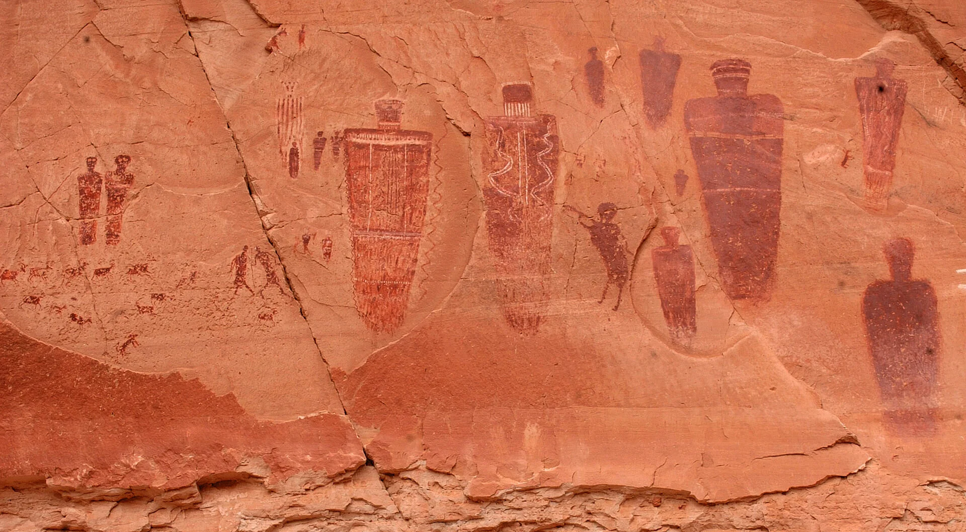
If you're fascinated by ancient history, Horseshoe Canyon is the district you won't want to miss. It’s located in the remote northwestern corner of Canyonlands National Park and best known for its remarkable collection of Barrier Canyon Style rock art, including some of the most intricate, well-preserved pictographs in all of North America.
The Great Gallery here is the best known and most spectacular panel and worth the trek getting there. At over 200 feet long, the extensive panel is extremely well-preserved containing life-size figures with intricate designs believed to be 1,500-4,000 years old. Learn more about the 7-mile hike getting there in my Guide to Canyonlands.
Unlike the other districts of Canyonlands, Horseshoe Canyon is all about the journey to one extraordinary destination. Although the access road is typically passable with a two-wheel-drive vehicle in dry conditions, don't rely on GPS to get you there. Cell service is nonexistent, and navigation apps can be unreliable. Be sure to bring a paper map or download offline maps before leaving.
Must-See Highlights
The Great Gallery
Barrier Canyon Style pictographs
Horseshoe Canyon Trail
👉 For more information on visiting Horseshoe Canyon, be sure to read my Complete Guide to Canyonlands National Park.
Best For
📜 Ancient rock art and history lovers
🥾 Day hiking in solitude
📸 Photography
Time Needed
Plan on spending at least 4–6 hours here which will give you time to hike to and marvel at the Great Gallery.
Distance from Moab
Approximately 2-1/2 to 3 hours from downtown Moab.
Difficulty
Moderate - Although the access road is usually suitable for 2-wheel-drive vehicles in dry weather, the hike into Horseshoe Canyon is approximately 7 miles round-trip with a steep descent into and climb out of the canyon.
⭐ My Recommendation
If you enjoy archaeology and history, Horseshoe Canyon is absolutely worth the long hike to see the Great Gallery. It’s surrounded by mysterious pictographs created thousands of years ago and perhaps the most unforgettable experiences in Canyonlands.
Frequently Asked Questions
Is there an entrance fee to visit Canyonlands National Park?
Visitors to Canyonlands must pay an entrance fee. A 7-day pass costs $30 per private vehicle, $25 per motorcycle, or $15 per person entering on foot or bicycle. Annual and lifetime National Park passes are also accepted.
Which Canyonlands district is the most popular?
Island in the Sky is the most accessible and popular district in the park due to its spectacular overlooks, easy access from Moab, and abundance of scenic viewpoints.
Which Canyonlands district is Mesa Arch located in?
Mesa Arch is located at Island in the Sky district.
Which district is closest to Moab?
Island in the Sky is the closest district to Moab, located about 35–45 minutes from downtown, making it an easy day trip.
Can you visit more than one district in a day?
Yes, but I don't recommend it. Although the districts appear close together on a map, there are no roads connecting them inside th park, and driving between them can take 2–6 hours. You will enjoy your trip more if you focus on just one district or at least one district each day.
Which district is best for families?
Island in the Sky is the best choice for families given its easy to navigate paved trails, short walks to overlooks, and promixmity to Moab.
Which districts require a 4-wheel drive vehicle?
A high-clearance 4-wheel drive vehicle is required for The Maze and many backcountry roads in The Needles. Horseshoe Canyon is typically accessible by 2-wheel drive in dry weather, but road conditions can change quickly especially after heavy rain.
More Utah National Park Guides
Complete Guide to Canyonlands National Park - Everything You Need to Know
Arches National Park Guide - The World’s Largest Concentration of Natural Stone Arches
Capitol Reef National Park - Utah’s Hidden Treasure
Ultimate Guide to Visiting Zion National Park - A Landscape Dominated by Steep Red Cliffs & The Virgin River
Zion National Park - How to Spend 5 Days Without the Crowds - The Itinerary You Need